Know when to plant with freeze/frost data

Freeze/Frost dataThe climate may be changing, but we still have winter. Gardeners in intemperate climes must know their planting “zone” and the projected date of the last frost to take full advantage of their abbreviated growing seasons. When is it safe for you to plant?  Click on “Frost /Freeze Data 1971-2001” to use the widget from NESDIS, the National Environmental Satellite, Data and Information Service, which will find station freeze/ frost probability tables for your state.

http://cdo.ncdc.noaa.gov/cgi-bin/climatenormals/climatenormals.pl

Predict your take-off time with FlightCaster.

FlightCasterWhat if there was a service that mixed current weather observations with ten years worth of data about flight delays and on-time airline ratings? And what if it combined all that information into a single number, a prediction about whether your flight will be delayed and by how long?

Welcome to FlightCaster, the free online “prediction” service that predicts up to six hours in advance the state of your flight. It’s not perfect, but it’s close enough to. It has an average 95% accuracy rate.

Use it online or download the mobile app. The FlightCaster iPhone app is available for free for now. http://itunes.apple.com/us/app/flightcaster-pro/id413164008?mt=8

http://flightcaster.com

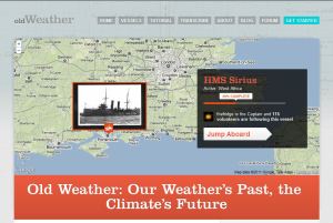
Old Weather invites us to transcribe 100 year old ship logs.

Old WeatherMilitary naval vessels record the weather six times a day. Because ships move around, we can think of them as de facto mobile weather stations. Britain’s National Archives has scanned the logs of 250 ships from the extended First World War period, from 1913 to 1923. Old Weather asks us to help transcribe these 250,000 log pages. What we find there will help scientists to understand what the weather was like 100 years ago. This reconstructed weather information may give us insight into climate change today.

http://www.oldweather.org

Help scientists measure the snowpack with Snowtweets!

SnowtweetsRichard Kelly, professor of geography at the University of Waterloo in Canada, wants to track climate change and predict the spring runoff but he needs your help. He says, “We’re asking people to really look around them when they’re outside and perhaps make a measurement of how much snow there is in their backyard, or on their way as they drive along. They can perhaps make an estimate of snow depth.”

Use Twitter to send a message about the snow, marking your tweet with the hashtag #snowtweets. Send the hashtag and your guess of the snow depth in centimeters or inches followed by your GPS coordinates or zip code. Your tweet should look like this:

#snowtweets 15 in. at 14226

Android and iPhone users can visit http://snowtweets.org/m to download the app for their smartphones.

Do your part to help the Department of Geography and Environmental Management at the University of Waterloo figure out the SWE (snow water equivalent) at various spatial scales and with different accuracies…with your Snowtweets!

http://snowcore.uwaterloo.ca/snowtweets/